Featuring Harjit Sheera, Martin Hunt and Peter Barnes
You have not yet given permission to place the required cookies. Accept the required cookies to view this content.
The energy and utilities industry is increasingly using space data to support the energy transition and deliver faster and better services at lower costs. In Part 5 of our Energy Transition Talks podcast series, CGI experts Harjit Sheera, Martin Hunt, and Peter Barnes explore the benefits and challenges of harnessing space data.
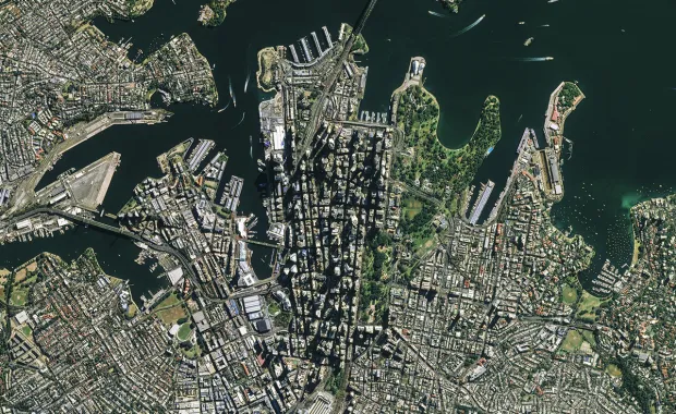
Satellites generate enormous volumes of data that energy and utility companies are looking to transform into actionable insights to support the energy transition and decarbonization initiatives. Examples range from combining satellite data with other sources, such as LIDAR, to enable accurate rooftop solar power generation calculations, and proactive and targeted management of infrastructure.
Using space data to advance micro-generation initiatives
In Northern Europe, says Martin, there is growing interest in micro-generation, especially from private households and apartment buildings. CGI's operations in Estonia support this transition by using open space data, provided either by satellites or light detection and ranging (LIDAR), to enable accurate rooftop solar power generation calculations.
"Based on this data, we can make quite precise calculations on what the solar energy production potential for each and every household would be," adds Martin.
He explains that evaluating a specific building's potential to generate electricity from solar panels requires analysis of the building's roof, angle, azimuth, and geographical location. Using Earth observation (EO) data, it becomes possible to create a three-dimensional model of the roof to detect such characteristics as well as any obstacles that may prevent mounting the panels. "Basically, you can calculate the total area suitable for the solar panels," says Martin.
It's also possible to calculate the amount of annual solar radiation and average temperatures in that specific region or location to predict potential production and assess if micro-generation is feasible.
Challenges of micro-generation
Micro-generation is not without challenges, particularly for grid owners. "Rooftop solar and all of the components that go into distributed energy resources (DERs) present significant challenges to the continued operation of utilities in the future,” says Peter. Distributed energy resource management systems, or DERMS, specifically handle data from DERs, whether it's rooftop solar, co-generation or other types of generation not managed directly by the utility. Taking this data and making the utilities' systems and back-office systems aware of the availability, the execution, and the power of these DERs is a key challenge for utilities moving ahead. Having as much comprehensive data about additional power generation methods beyond the utility's control can help maintain the stability of the network. However, there are commercial, financial and regulatory challenges that also come into play.
Optimizing operations and costs
Using space data will enable utilities to optimize further how they deliver power. The overarching challenge of DERs, in general, is that utilities still have to pay for everything, including the lines.
'With rooftop solar, utilities need to adapt to spend the money they have more efficiently because that money will continue to dwindle as more people take advantage of rooftop solar and similar initiatives," Peter explains. A key challenge to address is optimizing the truck roll:
"Whether it's using mapping, Earth-imaging information or telemetry, it's about ensuring that when a truck rolls, firstly, it's rolling to the right place, and that the sequence in which the work is executed is optimized to reduce the travel time and maximize the actual working time."
The benefits are myriad, not the least of which is controlling emissions and optimizing the deployment of field resources.
Uses for space data are opening up across industries
The volume, quality, and manipulation methods of satellite data are growing, and so are the applications across industries.
Using space data, either satellite imagery or LIDAR data, to monitor vegetation growth can reduce interference with power lines and manual inspections and target maintenance activities to minimize service interruption and loss of business. "It becomes possible to monitor vegetation growth proactively and to determine whether or not a given type of vegetation is susceptible to a certain wind speed, and then to instruct the utilities' vegetation management programs to proactively manage that vegetation in a very targeted and focused way," explains Peter.
However, says Martin, "EO and space data are not limited to the energy and utilities sector." For instance, EO data can help monitor sea ice and its generation and even predict ice movements to help mitigate disasters and support rescue work and sea navigation. Another application is in the agricultural domain. "It's possible to detect specific activities on the fields such as whether the fields have been plowed or the specific crop being grown, etc.," adds Martin.
Additionally, EO can be used to monitor and digitally inspect waterways using high-resolution satellite data, leading to significant reductions in labor costs. It can also be used to monitor, track and predict the response to oil spill incidents.
Currently, a lot of this data is collected manually, which is highly time-consuming. "It is not environmentally friendly either. So that's what the European Commission is pushing quite heavily at the moment and utilizing aerial monitoring more and more," says Martin.
Factors to be mindful of when combining different forms of data
The success of space data applications hinges on the type and quality of data used, the purpose of its use and the business decisions being made based on specific data sets. Satellite data, for instance, is available in near real-time, but other data sets, such as LIDAR, are less frequent, and their quality can vary based on geography. "LIDAR data gathering involves an actual aircraft flying over and performing the measurements and imaging. In such cases, the data can date back a few years, if not more," says Martin.
From a utility operations perspective, whether it's responding to natural disasters or keeping the lights on, integrating data about the real-time state of the network into the projections help to direct inspection and maintenance efforts, including predictive maintenance.
Therefore, whether the data sets are free or commercially available, how they are used and combined must be considered thoroughly to tailor applications to specific requirements.
Hi, welcome to CGI's Energy Transition Talks series of podcasts. I'm Harjit Sheera, Director of Corporate Services and Space, based in the UK. My usual role is the development of business within the space sector as part of the international space cabinet, but today, I will be exploring how the energy and utility sector is increasingly using space data in their solutions, along with the benefits and challenges this brings.
So, joining me today will be Martin Hunt, Sector Lead for utilities, space, and earth observation in CGI Estonia and Peter Barnes, Director within CGIs utilities delivery organization based in Montreal, Canada.
Chapter 2: How space data improve calculations for rooftop solar potential
Martin, may I start by asking you, what has led CGI Estonia to use space data to support their utility clients? And what kind of data is being used?
Martin Hunt:
The electricity demand and the growing interest towards micro generation, at least, here in Northern Europe. So, there is, certainly, interest in that, especially, from the private households and apartment buildings. And in order to help them out, and to guide them and support them regarding that. I think we could help them out by advising them what would be their micro-generation potential, overall. This is where, actually, the space domain steps in. We can learn quite a lot from that. We can use the open data provided to us by either the satellites or the LIDAR data. And based on that, we're able to make quite precise calculations. What would be the solar energy production potential for each and every household, basically?
Sheera:
What is the practical relevance of these calculations? And, what challenges does this create?
Hunt:
Well, I think it does pose a challenge to the grid owners. What would every household be doing with the energy that they are not using on-site? Can they sell the excess energy produced back to the grid? Is the grid capable of doing that? That's definitely one of the challenges.
Chapter 3: Space data and distribution management
Sheera:
Peter, let me bring you in here to get your perspective on how satellite data is affecting CGI utility clients in your area.
Peter Barnes:
Utility systems have been in a state of constant evolution over the last 100 years. We started off, at least in my neck of the woods, with relatively simple systems, such as outage management systems—things that allowed the utilities to respond to nascent problems on the grid. To respond, not proactively, but reactively to restore outages, to put back up service, let's say, tp manage the overall stability of the grid.
The utility industry has transitioned from outage management into network management where there is increased monitoring using SCADA systems and using telemetry from metering. Then that evolution continued into distribution management systems (DMS)—systems that, in addition to the telemetry, would also allow you to control the remotely controlled devices in the field. DMSs have now evolved into ADMSs, advanced distribution management systems, which contain a multitude of different functions geared not only towards fixing problems, but also proactively detecting problems that are on the network.
One of the components of those advanced distribution management systems has to do with renewables. distributed energy resource management systems, or DERMS as they're colloquially known. These are systems that specifically handle data from distributed energy resources (DERs), whether it's rooftop solar, co-generation, or whatever type of generation that isn't managed directly by the utility. Taking that data and making the utilities’ systems and back-office systems aware of the availability, execution, let's say, power of those distributed energy resources is a key challenge for utilities moving ahead. They don't own those resources, so being able to have as much comprehensive data about the operation of those resources ensures the utility can maintain the stability of its network. But there are other challenges, some commercial, some financial, some regulatory that also come into play. So, all in all, rooftop solar and all of the components that go into distributed energy resources do present some significant challenges to the continued operation of utilities in the future.
Sheera:
What can be done to address these challenges using space data?
Hunt:
The first stage of outage management, if I may say that, is preventing the issues happening on the network. One of the directions to look at, in that regard, would be utilizing the space data, either the satellite imagery or the LIDAR data, to monitor vegetation growth, for instance. Such things are definitely contributing to preventing issues from happening on the network.
Regarding solar production, of course, it's solar energy production. It's something that can be utilized on a small scale, you don't have to do it necessarily on the large scale. So, micro-generation is perfectly acceptable and that's the reason why solar energy is partly becoming increasingly important, and utilizing solar panels is increasingly popular here in our region, at least.
Chapter 4: Applications for space data in other industries
Sheera:
Can I ask how easily the application of space data can be transferred across other industries?
Hunt:
Yes, that's a good question. Because Earth observation overall and the space data are not limited to the utilities. But, maybe, I would illustrate that on the basis of the utilities case. For instance, if we would like to evaluate solar energy or micro-generation potential for a specific private household, let's say, we would have to analyze the roof of that building, the angle of that roof, the azimuth, the geographical location of that building, which gives us a lot of information about the amount of annual solar radiation and the average temperatures in that specific region or location. So this is something that you can do with Earth observation data. You can have the three-dimensional model of the surface, a roof, for instance, in our case, you can detect the angle, the azimuth, you can detect the obstacles on that roof which would prevent mounting the panels. So you can basically calculate the total area suitable for the solar panels.
And based on that filtering, again, the geographical location, the solar radiation and the temperatures, based on that data, you can make the actual predictions of the potential production, whether it's feasible or not.
I think that gives us quite a good example of what you can be doing in other areas. For instance, if we would like to monitor the sea ice, the generation of sea ice, or the types of sea ice, predict the ice movements, again, it can be easily done by utilizing the earth operation data and, as a result, helping out the rescue workers and the sea navigation.
Another example would be the agriculture domain. It's possible to detect the specific activities in the fields, whether the mowing has been done on time and so forth, or what's the specific crop that's being grown and so forth.
Chapter 5: Using data to improve efficiency for energy and utilities
Sheera:
So, I understand, a lot of this is all done manually at the moment, which is obviously very time-consuming.
Hunt:
It's all done manually, and it is time-consuming and not really environmentally friendly either. So that's what the European Commission is pushing quite heavily at the moment as well as utilizing aerial monitoring more and more and more.
Sheera:
Peter, can you add any further to this topic?
Barnes:
Yeah. Here in North America, well, in Canada, specifically, there's a vast amount of space, and we all tend to hug this narrow band next to the United States. But for a large swath of the country, overhead lines and overhead electricity delivery is really the norm. In the more urban areas, the more urban centers, Montreal, Toronto, Vancouver, etc., there's a lot underground, but everywhere else it's overwhelmingly overhead. As a result of that, we're highly sensitive, obviously, to the impacts of climate change and the increasing number of storms of large-scale events like ice storms and wind storms, that type of thing. We've even started seeing tornadoes in this neck of the woods, which was, just previously pretty much unheard of. So, the use of Earth-imaging data to, as Martin was mentioning, proactively monitor vegetation growth and to make determinations about whether or not a given type of vegetation is susceptible to a certain wind speed, and then to instruct vegetation management programs at the utilities that, again, proactively go out and manage that vegetation, not in a haphazard way, but in a very targeted and focused way, that becomes a lot more cost-effective for the utility.
One thing that isn't necessarily clear to the universe it's that, truck rolls cost money, whether you're talking about unionized or non-unionized personnel of the utility, every time that vehicle rolls a couple of feet outside of the dock, pretty much the meter starts ticking. So, one of the key challenges that CGI looks to address with our solutions is the optimization of the truck roll. So, whether it's using mapping, whether it's using Earth-imaging information, whether it's using telemetry that we're obtaining in real-time from field devices or automated meters, it's all about making sure that when that truck rolls, that it's rolling, first of all, to the right place, and also that if you are giving that truck a bunch of work, that the sequence in which that work is executed is optimized so as to reduce the travel time and maximize the actual working time.
The benefits of that are myriad, the least of which being emissions control because you're not unnecessarily driving around the geography. So, yes, there's definitely a lot of synchronicity between the Earth-imaging data that we can use and what we do in terms of optimizing that deployment of the field force at the utility.
Chapter 6: Key factors to consider when combining different forms of data
Martin, you already mentioned that you are combining satellite data with LIDAR data. What factors do you need to be mindful of when combining different forms of data?
Hunt:
Absolutely. I think it's almost important to keep in mind that we need to be knowledgeable about the data that we're using, what are the purposes that we're using it for, and what are the business decisions that we are making based on the specific data sets. For instance, the satellite data can be considered quite close to real-time data being updated every day or every other day, if we talk about the sentinels, for instance. If we talk about LIDAR data, then gathering that data involves the actual aircraft flying over and performing the measurements and performing the imaging. In such cases, the data can be dated back a few years, if not more. So, it depends on the region, on the country quite a lot. We need to keep in mind the data quality in every case, essentially, I would say.
Sheera:
Peter, can I also ask you the same question? What is the data that you are using? What are the constraints that you have around that, and how can you see that data needs to change to address further applications going forward?
Barnes:
Well, in general, utility operations, there's obviously a lot of emergency work that pops up whether it's storm events, natural disasters, that type of thing. But there's also just standard, keeping the lights on, business going on all the time, being able to use data from Earth imaging, whether it's drone data for inspections, whether it's satellite data from vegetation management, whether it's a LIDAR data, being able to integrate that data about the real-time state of the network into the projections that we make about where to direct our maintenance efforts, where to direct our inspection efforts and where to direct our preemptive maintenance efforts, that's really going to be able to drive a lot of economies at the utilities themselves. It's really going to be able to allow them to further optimize the way that they deliver power. The overarching challenge of distributed energy resources, in general, is that the utilities still have to pay for the lines, they still have to pay for everything. And if you've got rooftop solar you, essentially, are able to generate a lot of your own power. So, utilities need to adapt in order to spend the money that they have more efficiently because that money will continue to dwindle as more people take advantage of rooftop solar, and of similar initiatives.
Chapter 7: Summary of space data applications for energy and utilities
Sheera:
Our discussion today has highlighted that space data is increasingly being used to deliver faster and better services at lower costs. The examples with our energy and utility clients combine satellite data with other sources, such as LIDAR, enabling accurate rooftop solar power generation calculations, and proactive and targeted management of energy and utilities infrastructure.
The stability of networks can also be supported by the additional power generation methods beyond the control of the utility companies. However, this is dependent on utilities being able to accurately monitor and integrate this power into their networks. So, some evolution is required to maximize benefits.
Other examples using space data include the monitoring and digital inspection of waterways using high-resolution satellite data, leading to drastic reductions in labor costs. Another is the monitoring of vegetation to reduce interference with power lines, reduce manual inspections, and target maintenance activities to reduce incidents of service interruption and loss of business. Finally, the monitoring of oil spills to track and predict the response to oil spill incidents.
With all of these examples, a major factor to the success of these applications is the type and quality of the data used. Some are available in real-time, but other data sets are less frequent and of varying quality, based on geography. So, how we use and combine these data sets, some of which are free and others which are commercially available, must be considered thoroughly in order to tailor applications to specific requirements.
In any case, the volume, quality, and manipulation methods of satellite data are ever-increasing, and hence, so will the applications across all industries. Thanks for listening today and lookout for the next podcast in CGI's Energy Transition Talks series.
Martin
works
as
a
sector
lead
for
CGI’s
Energy
&
Utilities,
Space
and
Earth
observation
business
in
Estonia,
with
over
15
years
of
experience
in
IT
consulting
and
services.
In
those
sectors,
he
is
responsible
for
business
strategy,
client
relationship
...
Peter Barnes is the product manager responsible for the evolution of CGI’s PragmaSMART solution suite. He has 25 years of experience in the design and implementation of outage, network and workforce management solutions at various different utilities.
CGI’s rooftop solar energy generation calculator helps improv environmental sustainability by providing utilities, governments and other organizations with precise data, using advanced satellite, geospatial and utilities-industry technology.