Le rôle des données spatiales dans la transition énergétique
Mettant en vedette Harjit Sheera, Martin Hunt et Peter Barnes
You have not yet given permission to place the required cookies. Accept the required cookies to view this content.
Le secteur de l’énergie et des services publics utilise de plus en plus les données spatiales pour soutenir la transition énergétique et offrir des services à moindre coût de manière rapide et efficace. Dans la partie 5 de notre série Balado – Parlons transition énergétique, les experts de CGI Harjit Sheera, Martin Hunt et Peter Barnes explorent les avantages et les défis de l’exploitation des données spatiales.
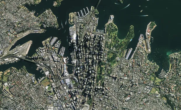
Les satellites génèrent d’énormes volumes de données que les sociétés d’énergie et de services publics cherchent à transformer en renseignements exploitables pour soutenir leurs initiatives de transition énergétique et de décarbonation. Il s’agit de combiner des données satellites avec d’autres sources, comme LiDAR, pour calculer avec exactitude la production d’énergie solaire sur toit et gérer de façon proactive et ciblée des infrastructures.
Données spatiales pour faire progresser les initiatives de microgénération
Martin explique qu’en Europe du Nord, on s’intéresse de plus en plus à la microgénération, surtout pour les ménages privés et les immeubles d’habitation. Les activités de CGI en Estonie appuient cette transition en utilisant des données spatiales ouvertes fournies par des satellites ou par détection et télémétrie de lumière (LiDAR) afin de calculer avec exactitude la production d’énergie solaire sur toit.
« À partir de ces données, nous pouvons calculer assez précisément le potentiel de production d’énergie solaire pour chaque ménage », affirme-t-il.
Il précise que pour évaluer le potentiel d’un ménage en particulier à produire de l’électricité à partir de panneaux solaires, il faut analyser le toit, l’angle, l’azimut et l’emplacement géographique du bâtiment. À l’aide des données d’observation de la Terre, il devient possible de créer un modèle tridimensionnel du toit pour détecter l’angle, l’azimut et tout obstacle qui pourrait nuire à l’installation des panneaux. « En gros, on peut calculer la superficie totale qui convient aux panneaux solaires », résume Martin.
Il est également possible de calculer la quantité de rayonnement solaire annuel et les températures moyennes dans une région ou un emplacement donné afin de prévoir la production potentielle et de juger si la microgénération est possible.
Défis de la microgénération
La microgénération, selon Martin, pose certains défis, particulièrement pour les propriétaires de réseaux. Peter est du même avis : « L’énergie solaire sur le toit et toutes les composantes qui entrent dans les ressources énergétiques distribuées présentent d’importants défis pour la continuité des services publics dans l’avenir. » Les systèmes de gestion des ressources énergétiques distribuées traitent spécifiquement les données sur ces ressources, qu’il s’agisse d’énergie solaire sur toit, de cogénération ou d’autres types de production qui ne sont pas gérés directement par les services publics. « À l’avenir, les services publics devront être en mesure d’utiliser ces données et d’informer les systèmes des services publics et d’arrière-guichet de leur disponibilité, de leur exécution et de leur pouvoir, ce qui représente un défi de taille. » Le fait de disposer de données exhaustives sur les méthodes de production d’énergie supplémentaires qui ne relèvent pas des services publics peut contribuer à maintenir la stabilité du réseau. « Cependant, il y a des défis commerciaux, financiers et réglementaires qui entrent aussi en jeu », ajoute-t-il.
Optimisation des activités et des coûts
Selon Peter, les données spatiales permettront aux services publics d’optimiser davantage leur façon de fournir l’électricité. Le principal défi des ressources énergétiques distribuées, en général, c’est que ce sont les services publics qui doivent encore payer pour tout, y compris les lignes. « Pour les panneaux solaires sur toit, les services publics doivent dépenser l’argent dont ils disposent de manière plus efficace, parce que ce budget continuera de diminuer à mesure que de plus en plus de gens profiteront de l’énergie solaire sur toit et d’initiatives similaires », explique-t-il.
L’un des principaux défis que CGI cherche à relever est l’optimisation du transport.
« Que ce soit en utilisant la cartographie, l’imagerie terrestre ou la télémétrie, il faut s’assurer que lorsqu’un camion roule, il est au bon endroit, et que la séquence d’exécution des travaux est optimisée pour réduire le temps de déplacement et maximiser le temps de travail réel. »
Les avantages sont nombreux, notamment le contrôle des émissions et l’optimisation du déploiement des ressources sur le terrain.
Mise à profit des données spatiales dans d’autres secteurs d’activité
Le volume, la qualité et les méthodes de manipulation des données satellites s’améliorent, tout comme les applications dans l’ensemble des secteurs d’activité.
L’utilisation de données spatiales, soit des images satellites ou des données LiDAR, pour surveiller la croissance de la végétation peut réduire les interférences avec les lignes électriques et le nombre d’inspections manuelles, en plus de cibler les activités d’entretien pour réduire les interruptions de service et les pertes d’activité. « Il devient possible de surveiller la croissance de la végétation de façon proactive et de déterminer si un type donné de végétation est susceptible ou non à une certaine vitesse du vent, puis de demander aux programmes de gestion de la végétation des services publics de gérer cette végétation de façon proactive et très ciblée », explique Peter.
Toutefois, reprend Martin, « l’utilité des données sur l’observation de la terre et l’espace ne se limite pas au secteur de l’énergie et des services publics ». Par exemple, elles peuvent aider à surveiller la glace de mer et sa formation, et même à prévoir ses mouvements pour atténuer les risques de catastrophes naturelles et faciliter les sauvetages et la navigation maritime. Une autre application, ajoute-t-il, est dans le domaine agricole. « Il est possible de détecter des activités précises dans les champs, par exemple s’ils ont été déneigés ou si une certaine culture y pousse. »
L’observation de la Terre peut également être utilisée pour surveiller et inspecter les voies navigables à l’aide de données satellites à haute résolution, ce qui réduit grandement les coûts de main-d’œuvre. Elle peut également servir à la surveillance des déversements d’hydrocarbures aux fins de suivi et de planification des interventions en cas d’incident.
Actuellement, une grande partie de ces données sont recueillies manuellement, ce qui demande beaucoup de temps. « Ce n’est pas écologique non plus. La Commission européenne pousse donc assez fortement dans cette direction et utilise de plus en plus la surveillance aérienne », affirme Martin.
Facteurs à prendre en compte lors de la combinaison de différentes formes de données
Le succès des applications de données spatiales repose sur le type et la qualité des données utilisées, l’objet de leur utilisation et les décisions opérationnelles prises en fonction d’ensembles de données particuliers. Par exemple, les données satellites sont disponibles en temps (presque) réel, mais d’autres ensembles de données, comme LiDAR, sont mis à jour moins fréquemment, et leur qualité peut varier selon la géographie. « La collecte de données LiDAR se fait par un avion qui effectue les mesures et l’imagerie en survolant une zone. Les données peuvent donc parfois remonter à quelques années, voire plus », précise Martin.
Pour ce qui est de l’exploitation des services publics, qu’il s’agisse d’intervenir en cas de catastrophes naturelles ou de garder les lumières allumées, Peter affirme que l’intégration des données sur l’état en temps réel du réseau dans les projections aide à orienter les efforts d’inspection et d’entretien, notamment la maintenance prédictive.
Par conséquent, que les ensembles de données soient gratuits ou disponibles sur le marché, il faut examiner attentivement la façon dont ils sont utilisés et combinés pour adapter les applications à des exigences particulières.
Hi, welcome to CGI's Energy Transition Talks series of podcasts. I'm Harjit Sheera, Director of Corporate Services and Space, based in the UK. My usual role is the development of business within the space sector as part of the international space cabinet, but today, I will be exploring how the energy and utility sector is increasingly using space data in their solutions, along with the benefits and challenges this brings.
So, joining me today will be Martin Hunt, Sector Lead for utilities, space, and earth observation in CGI Estonia and Peter Barnes, Director within CGIs utilities delivery organization based in Montreal, Canada.
Chapter 2: How space data improve calculations for rooftop solar potential
Martin, may I start by asking you, what has led CGI Estonia to use space data to support their utility clients? And what kind of data is being used?
Martin Hunt:
The electricity demand and the growing interest towards micro generation, at least, here in Northern Europe. So, there is, certainly, interest in that, especially, from the private households and apartment buildings. And in order to help them out, and to guide them and support them regarding that. I think we could help them out by advising them what would be their micro-generation potential, overall. This is where, actually, the space domain steps in. We can learn quite a lot from that. We can use the open data provided to us by either the satellites or the LIDAR data. And based on that, we're able to make quite precise calculations. What would be the solar energy production potential for each and every household, basically?
Sheera:
What is the practical relevance of these calculations? And, what challenges does this create?
Hunt:
Well, I think it does pose a challenge to the grid owners. What would every household be doing with the energy that they are not using on-site? Can they sell the excess energy produced back to the grid? Is the grid capable of doing that? That's definitely one of the challenges.
Chapter 3: Space data and distribution management
Sheera:
Peter, let me bring you in here to get your perspective on how satellite data is affecting CGI utility clients in your area.
Peter Barnes:
Utility systems have been in a state of constant evolution over the last 100 years. We started off, at least in my neck of the woods, with relatively simple systems, such as outage management systems—things that allowed the utilities to respond to nascent problems on the grid. To respond, not proactively, but reactively to restore outages, to put back up service, let's say, tp manage the overall stability of the grid.
The utility industry has transitioned from outage management into network management where there is increased monitoring using SCADA systems and using telemetry from metering. Then that evolution continued into distribution management systems (DMS)—systems that, in addition to the telemetry, would also allow you to control the remotely controlled devices in the field. DMSs have now evolved into ADMSs, advanced distribution management systems, which contain a multitude of different functions geared not only towards fixing problems, but also proactively detecting problems that are on the network.
One of the components of those advanced distribution management systems has to do with renewables. distributed energy resource management systems, or DERMS as they're colloquially known. These are systems that specifically handle data from distributed energy resources (DERs), whether it's rooftop solar, co-generation, or whatever type of generation that isn't managed directly by the utility. Taking that data and making the utilities’ systems and back-office systems aware of the availability, execution, let's say, power of those distributed energy resources is a key challenge for utilities moving ahead. They don't own those resources, so being able to have as much comprehensive data about the operation of those resources ensures the utility can maintain the stability of its network. But there are other challenges, some commercial, some financial, some regulatory that also come into play. So, all in all, rooftop solar and all of the components that go into distributed energy resources do present some significant challenges to the continued operation of utilities in the future.
Sheera:
What can be done to address these challenges using space data?
Hunt:
The first stage of outage management, if I may say that, is preventing the issues happening on the network. One of the directions to look at, in that regard, would be utilizing the space data, either the satellite imagery or the LIDAR data, to monitor vegetation growth, for instance. Such things are definitely contributing to preventing issues from happening on the network.
Regarding solar production, of course, it's solar energy production. It's something that can be utilized on a small scale, you don't have to do it necessarily on the large scale. So, micro-generation is perfectly acceptable and that's the reason why solar energy is partly becoming increasingly important, and utilizing solar panels is increasingly popular here in our region, at least.
Chapter 4: Applications for space data in other industries
Sheera:
Can I ask how easily the application of space data can be transferred across other industries?
Hunt:
Yes, that's a good question. Because Earth observation overall and the space data are not limited to the utilities. But, maybe, I would illustrate that on the basis of the utilities case. For instance, if we would like to evaluate solar energy or micro-generation potential for a specific private household, let's say, we would have to analyze the roof of that building, the angle of that roof, the azimuth, the geographical location of that building, which gives us a lot of information about the amount of annual solar radiation and the average temperatures in that specific region or location. So this is something that you can do with Earth observation data. You can have the three-dimensional model of the surface, a roof, for instance, in our case, you can detect the angle, the azimuth, you can detect the obstacles on that roof which would prevent mounting the panels. So you can basically calculate the total area suitable for the solar panels.
And based on that filtering, again, the geographical location, the solar radiation and the temperatures, based on that data, you can make the actual predictions of the potential production, whether it's feasible or not.
I think that gives us quite a good example of what you can be doing in other areas. For instance, if we would like to monitor the sea ice, the generation of sea ice, or the types of sea ice, predict the ice movements, again, it can be easily done by utilizing the earth operation data and, as a result, helping out the rescue workers and the sea navigation.
Another example would be the agriculture domain. It's possible to detect the specific activities in the fields, whether the mowing has been done on time and so forth, or what's the specific crop that's being grown and so forth.
Chapter 5: Using data to improve efficiency for energy and utilities
Sheera:
So, I understand, a lot of this is all done manually at the moment, which is obviously very time-consuming.
Hunt:
It's all done manually, and it is time-consuming and not really environmentally friendly either. So that's what the European Commission is pushing quite heavily at the moment as well as utilizing aerial monitoring more and more and more.
Sheera:
Peter, can you add any further to this topic?
Barnes:
Yeah. Here in North America, well, in Canada, specifically, there's a vast amount of space, and we all tend to hug this narrow band next to the United States. But for a large swath of the country, overhead lines and overhead electricity delivery is really the norm. In the more urban areas, the more urban centers, Montreal, Toronto, Vancouver, etc., there's a lot underground, but everywhere else it's overwhelmingly overhead. As a result of that, we're highly sensitive, obviously, to the impacts of climate change and the increasing number of storms of large-scale events like ice storms and wind storms, that type of thing. We've even started seeing tornadoes in this neck of the woods, which was, just previously pretty much unheard of. So, the use of Earth-imaging data to, as Martin was mentioning, proactively monitor vegetation growth and to make determinations about whether or not a given type of vegetation is susceptible to a certain wind speed, and then to instruct vegetation management programs at the utilities that, again, proactively go out and manage that vegetation, not in a haphazard way, but in a very targeted and focused way, that becomes a lot more cost-effective for the utility.
One thing that isn't necessarily clear to the universe it's that, truck rolls cost money, whether you're talking about unionized or non-unionized personnel of the utility, every time that vehicle rolls a couple of feet outside of the dock, pretty much the meter starts ticking. So, one of the key challenges that CGI looks to address with our solutions is the optimization of the truck roll. So, whether it's using mapping, whether it's using Earth-imaging information, whether it's using telemetry that we're obtaining in real-time from field devices or automated meters, it's all about making sure that when that truck rolls, that it's rolling, first of all, to the right place, and also that if you are giving that truck a bunch of work, that the sequence in which that work is executed is optimized so as to reduce the travel time and maximize the actual working time.
The benefits of that are myriad, the least of which being emissions control because you're not unnecessarily driving around the geography. So, yes, there's definitely a lot of synchronicity between the Earth-imaging data that we can use and what we do in terms of optimizing that deployment of the field force at the utility.
Chapter 6: Key factors to consider when combining different forms of data
Martin, you already mentioned that you are combining satellite data with LIDAR data. What factors do you need to be mindful of when combining different forms of data?
Hunt:
Absolutely. I think it's almost important to keep in mind that we need to be knowledgeable about the data that we're using, what are the purposes that we're using it for, and what are the business decisions that we are making based on the specific data sets. For instance, the satellite data can be considered quite close to real-time data being updated every day or every other day, if we talk about the sentinels, for instance. If we talk about LIDAR data, then gathering that data involves the actual aircraft flying over and performing the measurements and performing the imaging. In such cases, the data can be dated back a few years, if not more. So, it depends on the region, on the country quite a lot. We need to keep in mind the data quality in every case, essentially, I would say.
Sheera:
Peter, can I also ask you the same question? What is the data that you are using? What are the constraints that you have around that, and how can you see that data needs to change to address further applications going forward?
Barnes:
Well, in general, utility operations, there's obviously a lot of emergency work that pops up whether it's storm events, natural disasters, that type of thing. But there's also just standard, keeping the lights on, business going on all the time, being able to use data from Earth imaging, whether it's drone data for inspections, whether it's satellite data from vegetation management, whether it's a LIDAR data, being able to integrate that data about the real-time state of the network into the projections that we make about where to direct our maintenance efforts, where to direct our inspection efforts and where to direct our preemptive maintenance efforts, that's really going to be able to drive a lot of economies at the utilities themselves. It's really going to be able to allow them to further optimize the way that they deliver power. The overarching challenge of distributed energy resources, in general, is that the utilities still have to pay for the lines, they still have to pay for everything. And if you've got rooftop solar you, essentially, are able to generate a lot of your own power. So, utilities need to adapt in order to spend the money that they have more efficiently because that money will continue to dwindle as more people take advantage of rooftop solar, and of similar initiatives.
Chapter 7: Summary of space data applications for energy and utilities
Sheera:
Our discussion today has highlighted that space data is increasingly being used to deliver faster and better services at lower costs. The examples with our energy and utility clients combine satellite data with other sources, such as LIDAR, enabling accurate rooftop solar power generation calculations, and proactive and targeted management of energy and utilities infrastructure.
The stability of networks can also be supported by the additional power generation methods beyond the control of the utility companies. However, this is dependent on utilities being able to accurately monitor and integrate this power into their networks. So, some evolution is required to maximize benefits.
Other examples using space data include the monitoring and digital inspection of waterways using high-resolution satellite data, leading to drastic reductions in labor costs. Another is the monitoring of vegetation to reduce interference with power lines, reduce manual inspections, and target maintenance activities to reduce incidents of service interruption and loss of business. Finally, the monitoring of oil spills to track and predict the response to oil spill incidents.
With all of these examples, a major factor to the success of these applications is the type and quality of the data used. Some are available in real-time, but other data sets are less frequent and of varying quality, based on geography. So, how we use and combine these data sets, some of which are free and others which are commercially available, must be considered thoroughly in order to tailor applications to specific requirements.
In any case, the volume, quality, and manipulation methods of satellite data are ever-increasing, and hence, so will the applications across all industries. Thanks for listening today and lookout for the next podcast in CGI's Energy Transition Talks series.
Peter
Barnes
est
le
gestionnaire
de
produits
responsable
de
l’évolution
de
la
suite
de
solutions
PragmaSMART
de
CGI.
Il
possède
25
ans
d’expérience
en
conception
et
mise
en
œuvre
de
solutions
de
gestion
des
pannes,
des
réseaux
et
des
effectifs
...
Calculateur de production d’énergie solaire sur toit
CGI’s rooftop solar energy generation calculator helps improv environmental sustainability by providing utilities, governments and other organizations with precise data, using advanced satellite, geospatial and utilities-industry technology.